
Carte topographique Town of Berwick
Carte interactive
Cliquez sur la carte pour afficher l’altitude.
À propos de cette carte
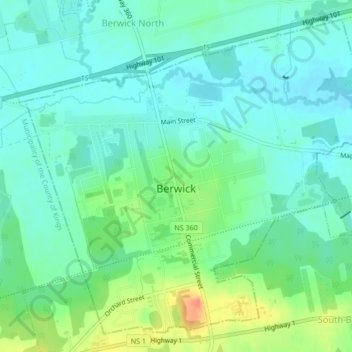
Nom : Carte topographique Town of Berwick, altitude, relief.
Lieu : Town of Berwick, Kings County, Nova Scotia, Canada (45.03328 -64.75432 45.05988 -64.71230)
Altitude moyenne : 37 m
Altitude minimum : 23 m
Altitude maximum : 70 m
Autres cartes topographiques
Cliquez sur une carte pour visualiser sa topographie, son altitude et son relief.
Town of Kentville
Canada > Nova Scotia > Kings County
Town of Kentville, Municipality of the County of Kings, Kings County, Nova Scotia, Canada
Altitude moyenne : 64 m
Kings County
Canada > Nova Scotia > Kings County
Kings County, Nova Scotia, Canada
Altitude moyenne : 109 m
Cloud Lake
Canada > Nova Scotia > Kings County > Cloud Lake
Cloud Lake, Municipality of the County of Kings, Kings County, Nova Scotia, Canada
Altitude moyenne : 200 m
Berwick
Canada > Nova Scotia > Kings County > Berwick
Berwick, Town of Berwick, Kings County, Nova Scotia, Canada
Altitude moyenne : 37 m
Kentville
Canada > Nova Scotia > Kings County > Kentville
Kentville, Town of Kentville, Kings County, Nova Scotia, B4N 4S4, Canada
Altitude moyenne : 64 m
Canaan
Canada > Nova Scotia > Kings County > Canaan
Canaan, Municipality of the County of Kings, Kings County, Nova Scotia, Canada
Altitude moyenne : 176 m
Halls Harbour
Canada > Nova Scotia > Kings County > Halls Harbour
Halls Harbour, Municipality of the County of Kings, Kings County, Nova Scotia, Canada
Altitude moyenne : 79 m