Géolocaliser

Carte topographique Niagara Escarpment

Cliquez sur la carte pour afficher l’altitude.

À propos de cette carte

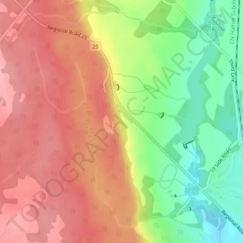
Nom : Carte topographique Niagara Escarpment, altitude, relief.

Lieu : Niagara Escarpment, Halton Hills, Halton Region, Golden Horseshoe, Ontario, L9T 2X7, Canada (43.56735 -79.96032 43.56745 -79.96022)

Altitude moyenne : 299 m

Altitude minimum : 231 m

Altitude maximum : 350 m

Autres cartes topographiques

Cliquez sur une carte pour visualiser sa topographie, son altitude et son relief.

Ottawa

Canada > Ontario

Ottawa, the capital city of Canada, is situated on the south bank of the Ottawa River at the confluence with the Rideau River. The city's topography is characterized by gently rolling terrain with elevations ranging from approximately 44 meters (144 feet) above sea level at the Ottawa River to its highest…

Altitude moyenne : 105 m

Mississauga

Canada > Ontario > Peel Region

The shoreline of former Glacial Lake Iroquois roughly follows the Dundas Street alignment, although it is not noticeable in some places but is more prominent in others, such as the site of the former brickyard (Shoreline Dr. near Mavis Rd.), the ancient shoreline promenteau affords a clear view of downtown…

Altitude moyenne : 151 m

Southwestern Ontario

Canada > Ontario

Altitude moyenne : 235 m

East York

Canada > Ontario > Toronto

Altitude moyenne : 123 m

Barrie

Canada > Ontario

On September 7, 1977, a private aircraft, flown by "Army" Hollingsworth, dropped altitude to 500 feet (152 m) in dense fog and struck CKVR's 1,000-foot (305 m) transmitter tower, killing all five people aboard the plane and destroying the tower and antenna. The station's 225-foot (69 m) auxiliary tower was…

Altitude moyenne : 265 m

Sault Ste. Marie

Canada > Ontario > Algoma District

Altitude moyenne : 249 m

Toronto

Canada > Ontario

Despite its deep ravines, Toronto is not remarkably hilly, but its elevation does increase steadily away from the lake. Elevation differences range from 76.5 metres (251 ft) above sea level at the Lake Ontario shore to 209 m (686 ft) above sea level near the York University grounds in the city's north end at…

Altitude moyenne : 139 m

Lake Ontario

Canada > Ontario

Lake Ontario is the easternmost of the Great Lakes and the smallest in surface area (7,340 sq mi, 18,960 km2), although it exceeds Lake Erie in volume (393 cu mi, 1,639 km3). It is the 13th largest lake in the world. When its islands are included, the lake's shoreline is 712 miles (1,146 km) long. As the last…

Altitude moyenne : 214 m

Algonquin Provincial Park

Canada > Ontario

Altitude moyenne : 386 m

Greater Sudbury

Canada > Ontario > Sudbury District

Altitude moyenne : 305 m

Wilmot

Canada > Ontario > Region of Waterloo

Altitude moyenne : 349 m

Barrie

Canada > Ontario > Barrie

Altitude moyenne : 248 m

Thunder Bay

Canada > Ontario > Thunder Bay District

Altitude moyenne : 240 m

Waterloo

Canada > Ontario > Region of Waterloo

Altitude moyenne : 341 m

Oshawa

Canada > Ontario > Durham Region

Altitude moyenne : 167 m

Kitchener

Canada > Ontario > Region of Waterloo

Kitchener is located in Southwestern Ontario, in the Saint Lawrence Lowlands. This geological and climatic region has wet-climate soils and deciduous forests. Situated in the Grand River Valley, the area is generally above 300 m (1,000 ft) in elevation.

Altitude moyenne : 336 m

Oakville

Canada > Ontario > Halton Region

Altitude moyenne : 104 m

Kingston

Canada > Ontario

Altitude moyenne : 112 m

Windsor

Canada > Ontario

Altitude moyenne : 183 m

Gravenhurst

Canada > Ontario > Muskoka District

Altitude moyenne : 244 m

Toronto

Canada > Ontario

Despite its deep ravines, Toronto is not remarkably hilly, but its elevation does increase steadily away from the lake. Elevation differences range from 76.5 metres (251 ft) above sea level at the Lake Ontario shore to 209 m (686 ft) ASL near the York University grounds in the city's north end at the…

Altitude moyenne : 139 m

Eastern Ontario

Canada > Ontario

Along the extreme western edge of Eastern Ontario is a continuation of the Laurentian Highlands, known as the Opeongo Hills, and they contain some of the highest elevations in Southern Ontario. They stretch into the northern portions of Central Ontario, near Algonquin Provincial Park.

Altitude moyenne : 243 m

Newmarket

Canada > Ontario > York Region

Newmarket's geographical coordinates are 44.05°N, 79.46°W, and its elevation above sea level is 252 m. It has an area of 38.33 km². The town is bounded on the south by Aurora, on the west by King, on the north by East Gwillimbury and on the east by Whitchurch–Stouffville.

Altitude moyenne : 270 m

Niagara Falls

Canada > Ontario > Niagara Region

Altitude moyenne : 179 m

North Bay

Canada > Ontario > Nipissing District

The climate in North Bay is common to most places in Northern Ontario. North Bay tends to be a less humid climate than that found in Southern Ontario due somewhat to the distance from the Great Lakes and less warm than some other locations in Northern Ontario due to cooling from Lake Nipissing. On May 31,…

Altitude moyenne : 266 m

Chatham-Kent

Canada > Ontario

Altitude moyenne : 183 m

Downsview Park

Canada > Ontario > Toronto

Altitude moyenne : 186 m

Orléans

Canada > Ontario > Ottawa > Cumberland

Altitude moyenne : 66 m

Port Hope

Canada > Ontario > Northumberland County

Altitude moyenne : 161 m

Tiny

Canada > Ontario > Simcoe County

Altitude moyenne : 191 m

Scarborough

Canada > Ontario > Toronto

Topographically, Scarborough is dominated by two watersheds, Highland Creek and the Rouge River. Highland Creek lies almost entirely within Scarborough and occupies approximately 70% of its total area. It occupies the western half of Scarborough, while the Rouge River flows through the eastern portion. Both of…

Altitude moyenne : 138 m

Northwestern Ontario

Canada > Ontario

Altitude moyenne : 221 m

Douro-Dummer

Canada > Ontario > Peterborough County

Altitude moyenne : 237 m

Severn River

Canada > Ontario > Muskoka District

Altitude moyenne : 224 m

Petawawa

Canada > Ontario > Renfrew County

Altitude moyenne : 152 m

Hamilton

Canada > Ontario

The airport's open, rural location and higher altitude results in lower temperatures, generally windier conditions, and higher snowfall amounts than lower, built-up areas of the city. The highest temperature ever recorded in Hamilton was 41.1 °C (106 °F) on July 14, 1868. The coldest temperature ever…

Altitude moyenne : 187 m

Renfrew County

Canada > Ontario

Altitude moyenne : 283 m

Lanark County

Canada > Ontario

Altitude moyenne : 167 m

Durham Region

Canada > Ontario

Altitude moyenne : 235 m

Grey County

Canada > Ontario

Altitude moyenne : 288 m

Muskoka District

Canada > Ontario

Altitude moyenne : 294 m

Kawartha Lakes

Canada > Ontario

Altitude moyenne : 274 m

Algonquin Highlands

Canada > Ontario > Haliburton County

Altitude moyenne : 399 m

Georgian Bay

Canada > Ontario

Altitude moyenne : 198 m

Laurentian Valley

Canada > Ontario > Renfrew County

Altitude moyenne : 181 m

Pickering

Canada > Ontario > Durham Region

The city covers an area of 231 square kilometres (89 sq mi) with an elevation of 89 metres (292 ft).

Altitude moyenne : 170 m

Meaford

Canada > Ontario > Grey County

Altitude moyenne : 222 m

Niagara Region

Canada > Ontario

Altitude moyenne : 148 m

Haliburton Lake

Canada > Ontario > Haliburton County > Dysart et al

Altitude moyenne : 392 m

St. Catharines

Canada > Ontario > Niagara Region

The most defining transportation icon of St. Catharines is the Welland Canal, a ship canal that runs 43.4 kilometres (27.0 mi), passing through the city. Four of its locks are within city boundaries. The canal allows shipping vessels to traverse the 99.5-metre (326.5 ft) drop in altitude from Lake Erie to Lake…

Altitude moyenne : 103 m

Dryden

Canada > Ontario > Kenora District

Altitude moyenne : 377 m

Burlington

Canada > Ontario > Halton Region

Altitude moyenne : 141 m

French River

Canada > Ontario > Sudbury District

Altitude moyenne : 208 m

Brampton

Canada > Ontario > Peel Region

Altitude moyenne : 223 m

Bracebridge

Canada > Ontario > Muskoka District

Altitude moyenne : 284 m

Tillsonburg

Canada > Ontario > Oxford County

Altitude moyenne : 239 m

Goderich

Canada > Ontario > Huron County

Altitude moyenne : 204 m

Sioux Lookout

Canada > Ontario > Kenora District

Altitude moyenne : 363 m

Sudbury

Canada > Ontario > Greater Sudbury

Altitude moyenne : 272 m

Brant County

Canada > Ontario

Altitude moyenne : 267 m

Manitoulin Island

Canada > Ontario > Manitoulin District

Altitude moyenne : 194 m

Madawaska River

Canada > Ontario > McNab/Braeside

Altitude moyenne : 176 m

Sleeping Giant Provincial Park

Canada > Ontario

Altitude moyenne : 207 m

Halton Region

Canada > Ontario

Altitude moyenne : 226 m

Kirkland Lake

Canada > Ontario > Timiskaming District

Kirkland Lake is located in the resource-rich Precambrian Shield, an ancient geological core of the North American continent. Nearby is the Arctic Watershed, a drainage divide at an elevation of 318 m (1,043 ft). Rivers south of that elevation flow into a drainage basin which includes Lake Ontario and the…

Altitude moyenne : 332 m

Perry Township

Canada > Ontario > Parry Sound District

Altitude moyenne : 352 m

Bay of Quinte

Canada > Ontario > Prince Edward County

Altitude moyenne : 99 m

Bark Lake

Canada > Ontario > Renfrew County > Madawaska Valley

Altitude moyenne : 373 m

Flamborough—Glanbrook

Canada > Ontario

Altitude moyenne : 241 m

Groom Lake

Canada > Ontario > Parry Sound District > Kearney

Altitude moyenne : 378 m

lac Seul

Canada > Ontario > Kenora District > Unorganized Kenora District

Lac Seul is a large, crescent shaped reservoir in Kenora District, northwestern Ontario, Canada. It is approximately 241 km (150 mi) long. It has a maximum (regulated) depth of 47.2 m, with a surface elevation of 357 m above sea level. Its level is raised in the summer and then drawn down in the winter months…

Altitude moyenne : 374 m

Thistle Lake

Canada > Ontario > Nipissing District

Altitude moyenne : 288 m

Trent River

Canada > Ontario > Northumberland County

Altitude moyenne : 158 m

Centre Wellington

Canada > Ontario > Wellington County

Altitude moyenne : 419 m

Orillia

Canada > Ontario

Altitude moyenne : 234 m

Central Ontario

Canada > Ontario

Along the northern edge of Central Ontario, are some of the highest elevations in Southern Ontario. These highlands are known as the Opeongo Hills, and they stretch into portions of Eastern Ontario as well.

Altitude moyenne : 255 m

Simcoe County

Canada > Ontario

The road network in Simcoe County is based on a grid pattern, with most roads running north–south or east–west. The topography of the land has permitted roads to be set in predominantly straight lines.

Altitude moyenne : 265 m

Haldimand County

Canada > Ontario

Altitude moyenne : 190 m

Pembroke

Canada > Ontario

Altitude moyenne : 128 m

Timmins

Canada > Ontario > Cochrane District

Altitude moyenne : 302 m

York Region

Canada > Ontario

Altitude moyenne : 243 m

Region of Waterloo

Canada > Ontario

Altitude moyenne : 348 m

Lambton

Canada > Ontario

Altitude moyenne : 188 m

Wasaga Beach

Canada > Ontario > Simcoe County

The Town of Wasaga Beach covers an area of 61.13 square kilometres (23.60 sq mi) comprised predominantly of sand and loamy sand that exhibit excessive to good drainage and irregular to moderately sloping topography. The poor soil quality makes it difficult to sustain lush lawns in the town. The Canada Land…

Altitude moyenne : 190 m

Gananoque

Canada > Ontario

Altitude moyenne : 84 m

Frontenac County

Canada > Ontario

Altitude moyenne : 169 m

Ottawa River

Canada > Ontario > Ottawa > Pontiac

Altitude moyenne : 318 m

Rainy River District

Canada > Ontario

Altitude moyenne : 406 m

Hastings County

Canada > Ontario

Altitude moyenne : 288 m

Lambton County

Canada > Ontario

Altitude moyenne : 200 m

Elgin County

Canada > Ontario

Altitude moyenne : 212 m

Niagara River

Canada > Ontario

Altitude moyenne : 160 m

Haliburton County

Canada > Ontario

Altitude moyenne : 392 m

Lake Nipigon

Canada > Ontario

Altitude moyenne : 307 m

Équipez-vous pour votre prochaine aventure :

🥤Gourdes réutilisables - Gourdes solides pour hydratation en randonnée et voyage
🆘Sifflet de Secours - Pour signaler votre position en cas d'urgence en montagne.
🔥Réchaud de Camping - Matériel de cuisson compact et rapide pour vos repas en bivouac.
💧Filtre à Eau Portable - Buvez l'eau des sources en toute sécurité avec une paille filtrante.
🧼Filtres à eau - Systèmes de filtration pour eau potable

En tant que Partenaire Amazon, ce site perçoit une commission sur les achats éligibles sans surcoût pour vous.