
Carte topographique Limerick City
Cliquez sur la carte pour afficher l’altitude.
À propos de cette carte
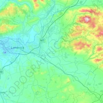
Nom : Carte topographique Limerick City, altitude, relief.
Lieu : Limerick City, County Limerick, Munster, Ireland (52.53981 -8.72616 52.75738 -8.18786)
Altitude moyenne : 102 m
Altitude minimum : -26 m
Altitude maximum : 690 m
Autres cartes topographiques
Cliquez sur une carte pour visualiser sa topographie, son altitude et son relief.
Kilcruaig
Ireland > County Limerick > The Municipal District of Cappamore — Kilmallock
Altitude moyenne : 200 m
Knockadea
Ireland > County Limerick > The Municipal District of Cappamore — Kilmallock
Altitude moyenne : 203 m
Pallasgreen
Ireland > County Limerick > The Municipal District of Cappamore — Kilmallock
Altitude moyenne : 72 m
Galtymore
Ireland > County Limerick > The Municipal District of Cappamore — Kilmallock
Galtymore or Galteemore (Irish: Cnoc Mór na nGaibhlte, meaning 'big hill of the Galtees') is a mountain in the province of Munster, Ireland. At 917.9 metres (3,011 ft 6 in), it is one of Ireland's highest mountains, being the 12th-highest on the Arderin list, and 14th-highest on the Vandeleur-Lynam list.…
Altitude moyenne : 594 m
Aherlow
Ireland > County Limerick > The Municipal District of Cappamore — Kilmallock
Altitude moyenne : 141 m
Limerick
Ireland > County Limerick > Limerick
Limerick's climate is classified as temperate oceanic (Köppen Cfb). Met Éireann maintains a climatological weather station at Shannon Airport, 20 kilometres west of the city in County Clare. Shannon Airport records an average of 977 millimetres of precipitation annually, most of which is rain. Limerick has a…
Altitude moyenne : 10 m
Clare Glens
Ireland > County Limerick > The Municipal District of Cappamore — Kilmallock
Altitude moyenne : 124 m
Knockawarriga
Ireland > County Limerick > The Municipal District of Newcastle West
Altitude moyenne : 247 m
Crecora
Ireland > County Limerick > The Municipal District of Adare — Rathkeale
Altitude moyenne : 37 m
Bleach Lough
Ireland > County Limerick > The Municipal District of Adare — Rathkeale
Altitude moyenne : 10 m
Ardpatrick
Ireland > County Limerick > The Municipal District of Cappamore — Kilmallock
Altitude moyenne : 169 m
Templeglantine
Ireland > County Limerick > The Municipal District of Newcastle West
Altitude moyenne : 189 m
Bruff
Ireland > County Limerick > The Municipal District of Cappamore — Kilmallock
Altitude moyenne : 68 m
Bruree
Ireland > County Limerick > The Municipal District of Cappamore — Kilmallock
Altitude moyenne : 62 m
Croom
Ireland > County Limerick > The Municipal District of Adare — Rathkeale > Croom
Altitude moyenne : 34 m
Tory Hill
Ireland > County Limerick > The Municipal District of Adare — Rathkeale
Altitude moyenne : 35 m