
Carte topographique Azumino
Carte interactive
Cliquez sur la carte pour afficher l’altitude.
À propos de cette carte
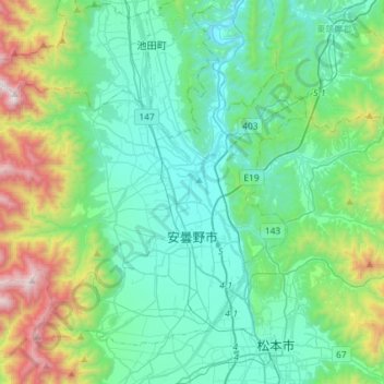
Nom : Carte topographique Azumino, altitude, relief.
Lieu : Azumino, Nagano Prefecture, Chubu Region, Japan (36.23736 137.70101 36.42535 137.99150)
Altitude moyenne : 854 m
Altitude minimum : 476 m
Altitude maximum : 2 235 m
Azumino is located in the Azumino Plateau on the northwestern end of the Matsumoto Basin, between mountain ranges to the west and east. The range of mountains on the western border is known as the Northern Alps (Hida Mountains) and is popular among hikers all over Japan. To the south is the city of Matsumoto, Nagano prefecture's second largest city. To the north lies the city of Ōmachi, and north of Ōmachi is the village of Hakuba. Hakuba was the site of many of the ski events during the 1998 Winter Olympic Games. Mount Jōnen at 2,857 metres (9,373 ft) is the highest elevation in the city.
Autres cartes topographiques
Cliquez sur une carte pour visualiser sa topographie, son altitude et son relief.
Mount Fuji
Japan > Sunto County > Oyama
Mount Fuji, Oyama, Sunto County, Shizuoka Prefecture, Chubu Region, Japan
Altitude moyenne : 3 261 m
Observation Deck (North Terminal)
Observation Deck (North Terminal), Osakaden, Itami, Hyogo Prefecture, Japan
Altitude moyenne : 21 m
Lake Ashi
Japan > Ashigarashimo County > Hakone
Lake Ashi, Hakone, Ashigarashimo County, Kanagawa Prefecture, Japan
Altitude moyenne : 869 m
Nishi Mera
Nishi Mera, Koyu County, Miyazaki Prefecture, Japan
Altitude moyenne : 656 m
Maborikaigan 4-chome Park
Maborikaigan 4-chome Park, Maboricho 3-chome, Yokosuka, Kanagawa Prefecture, 238-8550, Japan
Altitude moyenne : 22 m
Ibaraki
Ibaraki, Higashiibaraki County, Ibaraki Prefecture, 311-3116, Japan
Altitude moyenne : 26 m
Lake Sanaru
Lake Sanaru, Hamamatsu, Shizuoka Prefecture, Chubu Region, Japan
Altitude moyenne : 16 m
Motoyama
Motoyama, Nagaoka County, Kochi Prefecture, 781-3601, Japan
Altitude moyenne : 679 m
Setouchi
Setouchi, Oshima County, Kagoshima Prefecture, Japan
Altitude moyenne : 26 m
Higashishirakawa
Higashishirakawa, Kamo County, Gifu Prefecture, Chubu Region, 509-1392, Japan
Altitude moyenne : 658 m