
Carte topographique Takasaki
Carte interactive
Cliquez sur la carte pour afficher l’altitude.
À propos de cette carte
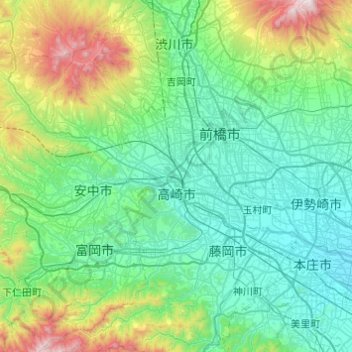
Nom : Carte topographique Takasaki, altitude, relief.
Lieu : Takasaki, Gunma Prefecture, Japan (36.19859 138.64251 36.48347 139.12966)
Altitude moyenne : 331 m
Altitude minimum : 36 m
Altitude maximum : 1 555 m
Takasaki is located in the southwestern part of Gunma Prefecture in the flat northwestern part of the Kantō Plain. The city is located approximately 90 to 100 kilometers from central Tokyo . Mount Akagi, Mount Haruna and Mount Myogi can be seen from the city, and the southern slopes of Mount Haruna are within the city limits. The Tone River, Karasu River and Usui River flow through the city. Although Takasaki is located over 100 kilometers from the coast, much of the city is low-lying, and the elevation of the city hall and central city area is only 97 meters above sea level. The land rises to the northern and western parts of the city to a maximum elevation of 1690 meters.
Autres cartes topographiques
Cliquez sur une carte pour visualiser sa topographie, son altitude et son relief.
Mount Fuji
Japan > Sunto County > Oyama
Mount Fuji, Oyama, Sunto County, Shizuoka Prefecture, Chubu Region, Japan
Altitude moyenne : 3 261 m
Observation Deck (North Terminal)
Observation Deck (North Terminal), Osakaden, Itami, Hyogo Prefecture, Japan
Altitude moyenne : 21 m
Lake Ashi
Japan > Ashigarashimo County > Hakone
Lake Ashi, Hakone, Ashigarashimo County, Kanagawa Prefecture, Japan
Altitude moyenne : 869 m
Nishi Mera
Nishi Mera, Koyu County, Miyazaki Prefecture, Japan
Altitude moyenne : 656 m
Maborikaigan 4-chome Park
Maborikaigan 4-chome Park, Maboricho 3-chome, Yokosuka, Kanagawa Prefecture, 238-8550, Japan
Altitude moyenne : 22 m
Ibaraki
Ibaraki, Higashiibaraki County, Ibaraki Prefecture, 311-3116, Japan
Altitude moyenne : 26 m
Lake Sanaru
Lake Sanaru, Hamamatsu, Shizuoka Prefecture, Chubu Region, Japan
Altitude moyenne : 16 m
Motoyama
Motoyama, Nagaoka County, Kochi Prefecture, 781-3601, Japan
Altitude moyenne : 679 m
Setouchi
Setouchi, Oshima County, Kagoshima Prefecture, Japan
Altitude moyenne : 26 m
Higashishirakawa
Higashishirakawa, Kamo County, Gifu Prefecture, Chubu Region, 509-1392, Japan
Altitude moyenne : 658 m