
Carte topographique Yokohama
Carte interactive
Cliquez sur la carte pour afficher l’altitude.
À propos de cette carte
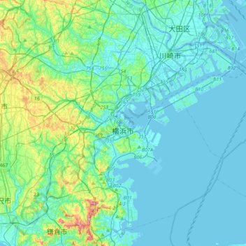
Nom : Carte topographique Yokohama, altitude, relief.
Lieu : Yokohama, Kanagawa Prefecture, 231-0017, Japan (35.31250 139.46478 35.59285 139.77693)
Altitude moyenne : 23 m
Altitude minimum : -9 m
Altitude maximum : 146 m
Yokohama has a total area of 437.38 km2 (168.87 sq mi) at an elevation of 5 metres (16 ft) above sea level. It is the capital of Kanagawa Prefecture, bordered to the east by Tokyo Bay and located in the middle of the Kantō plain. The city is surrounded by hills and the characteristic mountain system of the island of Honshū, so its growth has been limited and it has had to gain ground from the sea. This also affects the population density, one of the highest in Japan with 8,500 inhabitants per km2.
Autres cartes topographiques
Cliquez sur une carte pour visualiser sa topographie, son altitude et son relief.
Mount Fuji
Japan > Sunto County > Oyama
Mount Fuji, Oyama, Sunto County, Shizuoka Prefecture, Chubu Region, Japan
Altitude moyenne : 3 261 m
Ibaraki
Ibaraki, Higashiibaraki County, Ibaraki Prefecture, 311-3116, Japan
Altitude moyenne : 26 m
Maborikaigan 4-chome Park
Maborikaigan 4-chome Park, Maboricho 3-chome, Yokosuka, Kanagawa Prefecture, 238-8550, Japan
Altitude moyenne : 22 m
Lake Sanaru
Lake Sanaru, Hamamatsu, Shizuoka Prefecture, Chubu Region, Japan
Altitude moyenne : 16 m
Motoyama
Motoyama, Nagaoka County, Kochi Prefecture, 781-3601, Japan
Altitude moyenne : 679 m
Setouchi
Setouchi, Oshima County, Kagoshima Prefecture, Japan
Altitude moyenne : 26 m
Higashishirakawa
Higashishirakawa, Kamo County, Gifu Prefecture, Chubu Region, 509-1392, Japan
Altitude moyenne : 658 m
Nishikigaoka-chuo Park
Nishikigaoka-chuo Park, Nishikigaoka 2-chome, Aoba Ward, Sendai, Miyagi Prefecture, Japan
Altitude moyenne : 197 m