
Carte topographique Nara
Carte interactive
Cliquez sur la carte pour afficher l’altitude.
À propos de cette carte
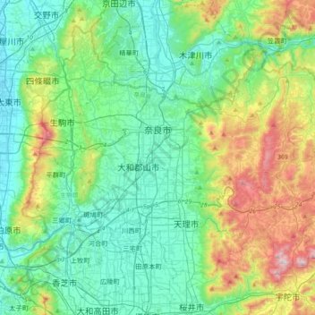
Nom : Carte topographique Nara, altitude, relief.
Lieu : Nara, Nara Prefecture, Japan (34.55805 135.71313 34.75774 136.07108)
Altitude moyenne : 195 m
Altitude minimum : 1 m
Altitude maximum : 784 m
The highest point in the city is at the peak of Kaigahira-yama at an altitude of 822.0 m (2,696.85 ft) (Tsugehayama-cho district), and the lowest is in Ikeda-cho district, with an altitude of 56.4 m (185.04 ft).
Autres cartes topographiques
Cliquez sur une carte pour visualiser sa topographie, son altitude et son relief.
Mount Fuji
Japan > Sunto County > Oyama
Mount Fuji, Oyama, Sunto County, Shizuoka Prefecture, Chubu Region, Japan
Altitude moyenne : 3 261 m
Ibaraki
Ibaraki, Higashiibaraki County, Ibaraki Prefecture, 311-3116, Japan
Altitude moyenne : 26 m
Maborikaigan 4-chome Park
Maborikaigan 4-chome Park, Maboricho 3-chome, Yokosuka, Kanagawa Prefecture, 238-8550, Japan
Altitude moyenne : 22 m
Lake Sanaru
Lake Sanaru, Hamamatsu, Shizuoka Prefecture, Chubu Region, Japan
Altitude moyenne : 16 m
Motoyama
Motoyama, Nagaoka County, Kochi Prefecture, 781-3601, Japan
Altitude moyenne : 679 m
Setouchi
Setouchi, Oshima County, Kagoshima Prefecture, Japan
Altitude moyenne : 26 m
Higashishirakawa
Higashishirakawa, Kamo County, Gifu Prefecture, Chubu Region, 509-1392, Japan
Altitude moyenne : 658 m
Nishikigaoka-chuo Park
Nishikigaoka-chuo Park, Nishikigaoka 2-chome, Aoba Ward, Sendai, Miyagi Prefecture, Japan
Altitude moyenne : 197 m