
Carte topographique Kyushu
Carte interactive
Cliquez sur la carte pour afficher l’altitude.
À propos de cette carte
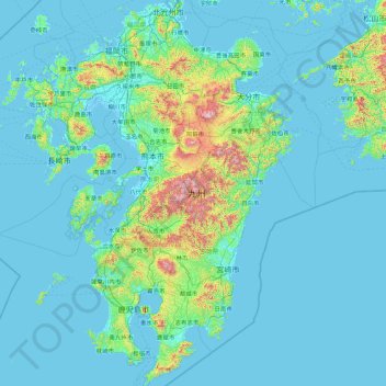
Nom : Carte topographique Kyushu, altitude, relief.
Lieu : Kyushu, Japan (30.99427 129.55263 33.96988 132.08533)
Altitude moyenne : 116 m
Altitude minimum : -4 m
Altitude maximum : 1 741 m
The total area is 36,782.37 km2 (14,201.75 sq mi) which makes it the 37th largest island in the world. It's slightly larger than Taiwan island 35,808 km2 (13,826 sq mi). The highest elevation is 1791 meters (5876 feet) on Mount Kujū.
Autres cartes topographiques
Cliquez sur une carte pour visualiser sa topographie, son altitude et son relief.
Mount Fuji
Japan > Sunto County > Oyama
Mount Fuji, Oyama, Sunto County, Shizuoka Prefecture, Chubu Region, Japan
Altitude moyenne : 3 261 m
Ibaraki
Ibaraki, Higashiibaraki County, Ibaraki Prefecture, 311-3116, Japan
Altitude moyenne : 26 m
Maborikaigan 4-chome Park
Maborikaigan 4-chome Park, Maboricho 3-chome, Yokosuka, Kanagawa Prefecture, 238-8550, Japan
Altitude moyenne : 22 m
Lake Sanaru
Lake Sanaru, Hamamatsu, Shizuoka Prefecture, Chubu Region, Japan
Altitude moyenne : 16 m
Motoyama
Motoyama, Nagaoka County, Kochi Prefecture, 781-3601, Japan
Altitude moyenne : 679 m
Setouchi
Setouchi, Oshima County, Kagoshima Prefecture, Japan
Altitude moyenne : 26 m
Higashishirakawa
Higashishirakawa, Kamo County, Gifu Prefecture, Chubu Region, 509-1392, Japan
Altitude moyenne : 658 m
Nishikigaoka-chuo Park
Nishikigaoka-chuo Park, Nishikigaoka 2-chome, Aoba Ward, Sendai, Miyagi Prefecture, Japan
Altitude moyenne : 197 m