
Carte topographique Mutsu
Carte interactive
Cliquez sur la carte pour afficher l’altitude.
À propos de cette carte
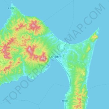
Nom : Carte topographique Mutsu, altitude, relief.
Lieu : Mutsu, Aomori Prefecture, Japan (41.04237 140.69555 41.56011 141.33897)
Altitude moyenne : 79 m
Altitude minimum : -2 m
Altitude maximum : 848 m
Mutsu occupies most of Shimokita Peninsula and is bordered by Mutsu Bay to the south and Tsugaru Strait to the north, and is the northernmost city on the island of Honshū. The volcanic Osorezan Mountain Range extends across the western and central portion of the city, and includes a number of caldera lakes. Mount Hiuchidake, 781 meters above sea level, is on the north side, and Mount Osore is on the south side. At the center of Mount Osore is a caldera with a diameter of about 3 kilometers, inside which is a caldera lake called Lake Usori. Mount Kamabu (elevation 879 m) is located southeast of the caldera's outer rim, and is the highest point of Mount Osore. The Tanabe River, which originates from the Shimokita Hills, flows through Tanabu, the center of Mutsu City, and the Tanabe Plain spreads out in the basin. The population is concentrated in the Tanabe, Ōhira, and Ōminato neighborhoods. Ōminato is located at the foot of Mount Kamabu, facing Ōminato Bay, where the waves are calm. There is a sand spit called Ashizaki in Ōminato Bay, and the inside of the sand spit is called Ashizaki Bay, which is a natural harbor. The Shimokita hills stretch in the southeastern part of the city.
Autres cartes topographiques
Cliquez sur une carte pour visualiser sa topographie, son altitude et son relief.
Mount Fuji
Japan > Sunto County > Oyama
Mount Fuji, Oyama, Sunto County, Shizuoka Prefecture, Chubu Region, Japan
Altitude moyenne : 3 261 m
Ibaraki
Ibaraki, Higashiibaraki County, Ibaraki Prefecture, 311-3116, Japan
Altitude moyenne : 26 m
Maborikaigan 4-chome Park
Maborikaigan 4-chome Park, Maboricho 3-chome, Yokosuka, Kanagawa Prefecture, 238-8550, Japan
Altitude moyenne : 22 m
Lake Sanaru
Lake Sanaru, Hamamatsu, Shizuoka Prefecture, Chubu Region, Japan
Altitude moyenne : 16 m
Motoyama
Motoyama, Nagaoka County, Kochi Prefecture, 781-3601, Japan
Altitude moyenne : 679 m
Setouchi
Setouchi, Oshima County, Kagoshima Prefecture, Japan
Altitude moyenne : 26 m
Higashishirakawa
Higashishirakawa, Kamo County, Gifu Prefecture, Chubu Region, 509-1392, Japan
Altitude moyenne : 658 m
Nishikigaoka-chuo Park
Nishikigaoka-chuo Park, Nishikigaoka 2-chome, Aoba Ward, Sendai, Miyagi Prefecture, Japan
Altitude moyenne : 197 m